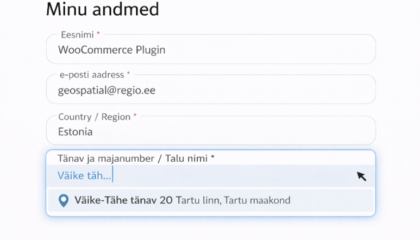
Blog

Adding an address should be as easy as possible for online store users!
Anne Kokk, the head of our geospatial data unit, wrote a piece for the Estonian E-Commerce Association’s website about how adding an address search option to an online store makes life easier for both the client and the delivery driver. Here’s what she wrote about address input: In just about every online store, you fill … Continued

Regio’s Baltic navigation data are the most precise available and helps reduce logistics costs
Have you ever found that the details of the roads or address dataset in your logistics software are insufficient or leads your drivers to the wrong location? Route planning and dispatch solutions based on data that are inaccurate or uneven in terms of quality waste both your time and money. We all know the inconvenience … Continued

New web solution for the translation of place names
Regio and Jāņa sēta, the largest map publisher in Latvia, have collaborated to create TerraLexicon – an automatic translation solution that allows the translation of place names on maps into multiple languages directly within the design file. Our partnership to develop the new translation service began a year and a half ago. The idea for … Continued

Fishing game app “Kalamäng”
“Kalamäng” is a mobile application created in 2013 that provides a comprehensive overview of the fish species living in Estonian waters.The application was developed by the Fisheries Information Centre in collaboration with Mooncascade and Regio. It’s since been given a makeover, thanks to which it can be used on all the latest smart devices. The … Continued

450 maps for the GO travel magazine
The partnership between Regio and GO began 18 years ago with the publication of the very first issue of the GO travel magazine (now Estonia’s highest-selling travel and hiking periodical) back in 2005. In the intervening years Regio has produced almost 450 maps for the magazine – an average of four or five per issue. … Continued

Regio’s new Estonian Road Atlas marks 25 years since its original publication
Regio’s recently released Estonian Road Atlas is like a mid-term review of life in the country. Printed atlases still very much have a place alongside digital versions. Apart from anything else, Regio’s road atlases never run out of battery and aren’t dependent on mobile coverage! They’re very handy for making travel plans at home, and … Continued

A web map is a great visualizer – the story of the pharmacy map application
It started in August 2019, when we were approached to develop a map application that would provide an overview of the locations of pharmacies around Estonia. More important than the location details themselves was the visual representation of information related to the then forthcoming pharmacy reforms: whether specific pharmacies met the requirements coming into force … Continued

15 years of Regio’s Garmin maps
The earliest versions of maps based on official Garmin technology were published by Regio in 2008. Maps produced without navigation guidance, using third-party software, had already been created in Estonia, but the first proper Estonian data reached Garmin’s Navigator Europe through the Navteq company in 2008, and even those were sourced from Regio. Why are separate … Continued