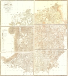
Description
Reprint of the Saaremaa Atlas issued by the Saaremaa Land Regulation and Audit Commission in 1836.
The reprint of the Saaremaa Atlas, published in January 2019, is dedicated to the 90th birthday of Professor of History Herbert Ligi.
The original Atlas was found by historian Aadu Must in the St. Petersburg State Historical Archive in St. Petersburg. The maps were prepared for printing by Regio cartographers.
The set includes of 14 maps on open sheets: 13 maps of parishes and the general map of Saaremaa.
- It is possible to order the maps also sheet by sheet.
- Some of the maps are on two sheets
Available maps and dimensions:
- Karja – 99 x 63 (h) cm
- Jaani – 99 x 63 (h) cm
- Pöide – 99 x 68 (h) cm
- Valjala – 99 x 63 (h) cm
- Püha – 99 x 79 (h) cm (on two sheets)
- Kaarma – 99 x 110 (h) cm (on two sheets)
- Kärla – 99 x 64 (h) cm
- Mustjala – 99 x 63 (h) cm
- Kihelkonna – 99 x 104 (h) cm (on two sheets)
- Anseküla – 99 x 79 (h) cm (on two sheets)
- Jämaja – 99 x 63 (h) cm
- Muhu – 99 x 63 (h) cm
- Ruhnu – 99 x 63 (h) cm
You can order the whole set or ready-made maps page by page here.
Original title of the atlas: Atlas von der zu dem Liefländischen Gouvernement gehörigen Province Oesel so wie dieselbe auf Allerhöchst Namentlichen Befehl Kayserlicher Majestaet aufgemessen und in ihren einzelnen Kirchspielen regulirt worden ist. Angefertiget in der Allerhöchst verordneten Oeselschen Landes Regulirungs-Expedition im Jahre MDCCCXXXVI.
The originals are in Petersburg State Historical Archive 380-14-15 and National Archive EAA 311-1-560.