Regio has specialized in creating up-to-date and easily read maps for more than 30 years. We produce printed maps, maps for Garmin GPS devices and develop map applications. Regio has the continuously updated database of Estonia and the Baltic States. Due to this we can provide our clients with a wide range of maps that are accurate, up-to-date, and compiled to meet our customers needs.
Classroom maps, the periodic table, units conversion table. Maps and tables come in a range of different sizes and finishes.
Bespoke maps for customers who require more detailed or specific maps. The map can include data from Regio’s extensive database as well as the customer’s own data.
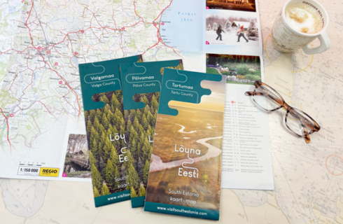
Folded maps, maps for tourist brochures, wayfinding maps etc – Regio offers complete solutions from compiling the map to arranging the printing.
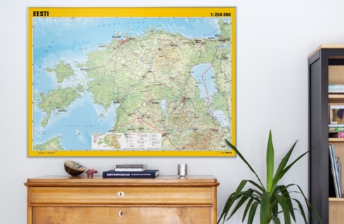
Wall Maps
A beautiful wall map brightens up the whole room and serves not just as an attractive decor feature but also as an interactive learning tool, encouraging kids to explore the world.
Regio’s online store offers wide selection of wall maps in different sizes and finishes. In addition we create bespoke maps according to customers specific requests.
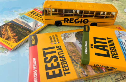
Atlases, Travel Guides, Road Maps
The first edition of Regio’s Estonian Road Atlas was published in 1994. Since then it has been the best-selling atlas of Estonia for decades, with 25 updated editions published for now. Paper atlas is a reliable, antifragile solution, offering the big-picture perspective, never runs out of power like smartphone can and it doesn’t need batteries or an internet.
In addition to atlases, Regio offers a selection of road maps of Estonia, Finland, and Europe, as well as travel guides.
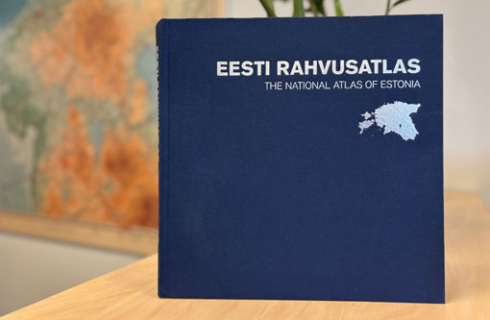
The National Atlas of Estonia
The first national atlas of Estonia contains nearly 500 historical and contemporary maps along with fascinating explanations that help to give meaning to Estonian nature, culture and history. All texts in the National Atlas of Estonia are in Estonian and English.
The National Atlas of Estonia was born in cooperation with geographers from the University of Tartu and map makers from Regio. The Atlas is dedicated to the 100th anniversary of the Estonia’s National University and of Estonian-language geography.
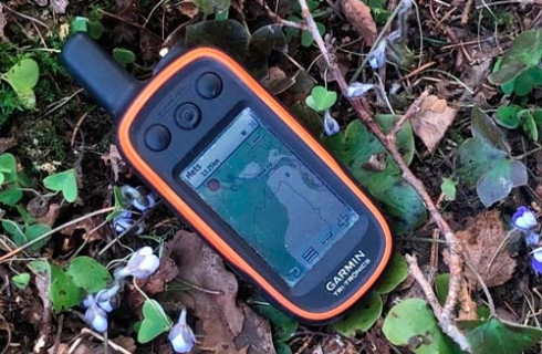
GPS Maps
Regio creates GPS maps for Garmin devices under license from Garmin. The maps are available on microSD memory cards, version updates are delivered as .img files.
List of GPS maps:
- Estonian Road Map
- Estonian Topographic Map
- Baltic Road Map
- Boundaries of Forest Allocations of Estonia
- Cadastral Unit Boundaries of Estonia
Upon customers requests we create additional map layers which can include areas, line features and point features.
Bespoke Maps
We create bespoke maps according to customers specific requests. Our service covers everything from compiling the map to the designed brochure, poster or leaflet, either as a file or printed. A folded locator map or a tear-off pad is a user-friendly for travellers and cost effective solution for the hotels and tourism industry to promote the area.
We provide a complete solution:
- Creating the maps and texts for travel brochures.
- Editing and translating texts.
- Finding images for promotional maps.
- Designing and printing the promotional maps.
- At the request of the customer, we provide only the map file or arrange the printing.
We also provide digital solutions: map files for printed materials like travel guides, brochures, leaflets etc, as well as for websites. Map files are sold under license.
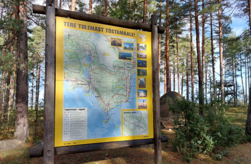
Wayfinding Maps
A wayfinding map helps people figure out how to get to their destination and encourages visitors to explore more of the area, especially less obvious spots. We offer complete solution—creating and designing the map, as well as printing and finishing.
- A map introducing a manor, castle, or other landmark.
- A map of the city center helps visitors locate attractions and interesting sites.
- Public beach access map, showing walkways, nearby facilities and parking areas.
- Map of cemetery, showing the layout of gravesites with roads and walkways, and the final resting place of notable figures such as composers, artists, scientists and historical figures.
Map App Regio kaart
The free Regio Map app (Regio kaart) is the most accurate and up-to-date map application for the Baltic States, available for both Android and iOS devices. A web version of the app is available as well.
- Includes constantly updated spatial data of the Baltic States.
- Enables quick and precise location determination.
- Perfect solution for hikers, travelers, and anyone else who needs a reliable map.

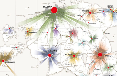
Data Visualization and Data-driven Thematic Maps
We create thematic maps based on both Regio’s and client data. Thematic mapping helps visually analyze complex data, patterns, and trends in geographic areas.
Thematic maps are used in many fields, including:
- Planning and Infrastructure—used by municipalities and urban planners.
- Environment and Science—for analyzing natural phenomena and climate patterns.
- Tourism industry and Business—to show destinations and tourism statistics.
- Real Estate and Transport—for market research and location-based analysis.
Thematic maps are created on demand. These maps can combine spatial data layers with digital solutions, so that the result can be integrated into map applications. Available formats include density maps, contour maps as well as 3D maps.
Thematic maps provide a quick and clear overview of spatial information, helping to make better decisions.
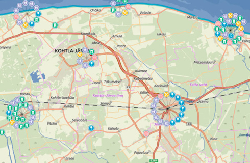
Map Applications
A map application is an excellent tool for visualizing data and information. Regio develops map applications for web browsers, mobile devices and desktop applications. These applications allow users to filter map data, display various map layers and dynamically navigate.
Based on the need of users, we create static, as well as interactive map applications, focusing on user-friendly design. Just like with paper maps, clarity and comprehensibility are essential in digital solutions.
Automated Translation Solution for Names
Automated translation solution TerraLexicon is focused on translation of geographical names. The uniqueness of the service is in replacing the original names with the translated ones directly in the vector graphic file, significantly reducing the time and cost needed for editing. The file being translated does not leave your computer. Names are taken into the translation environment and then returned to the design file through the Adobe Illustrator plugin. This ensures that no one else gains access to your original file.
TerraLexicon was developed within the framework of the Estonia-Latvia cross-border cooperation program, in collaboration with the Latvian cartography and geoinformatics company SIA “Jāņa sēta”.
The visual showcase of some of the key features of TerraLexicon can be seen in this video.

Automated name translation service TerraLexicon was developed as part of the Interreg Estonia-Latvia Cross-Border Cooperation Program 2014-2020 project “Geoname Translator for Maps” (Est-Lat 112).

