
 EST
 GER
Regio Drone Maps
Automatic Translation by ChatGPT
Drones are here to stay
Just a few years ago, drones were mainly toys for enthusiasts. Today, they have become essential tools used by forestry professionals, surveyors, construction companies, rescue teams, farmers and real estate photographers. Their user base and range of applications continue to grow every year.
The numbers tell the same story. Estonia is estimated to have around 15,000 consumer drones, while more than 8,000 drone pilots are registered with the Estonian Transport Administration. The actual number of drone operators is even higher. In 2025, the European commercial drone market was valued at USD 7.58 billion, with forecasts predicting nearly twofold growth to USD 15.23 billion by 2031.
Why is the drone industry growing so rapidly?
- Technology has become affordable and powerful. A drone equipped with a professional camera, thermal imaging camera or RTK positioning technology costs only a fraction of what it would take to carry out the same work using a helicopter or aircraft.
- Time and safety. A drone can survey an area in just a few dozen minutes – an area that would take hours to cover on foot. There is no need for people to enter bogs, climb onto roofs or approach high-voltage power lines.
- Data is valuable. Data is valuable. Data collected by drones is much more than just imagery. Orthophotos, 3D models and monitoring data form the basis for everyday decision-making in forestry, construction and agriculture.
Why drone maps?
Today, maps are no longer defined by the device or application in which they are used. A map is a map, whether it is on paper, online, in a navigation device, a GIS system or a drone controller.
Professional DJI drone controllers come with a general basemap. However, this is often not sufficient for use in Estonia. The basemap lacks the necessary level of detail, not to mention thematic information such as cadastral boundaries or forest stand boundaries. In addition, there are areas in Estonia where mobile internet coverage is poor or completely unavailable.
Three map layers for your drone controller
Regio Drone Maps consist of three complementary map layers that can be used individually or together. All layers work with the DJI Pilot 2 app on compatible controllers (such as the DJI RC Plus and RC Pro Enterprise) and are available offline.
They are not compatible with the DJI Fly app used by consumer drones.
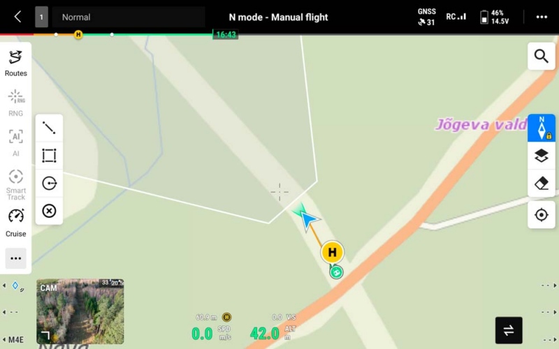
Regio Estonia Basemap
The basemap is the foundation of the Regio Drone Maps solution. Covering the entire territory of Estonia, it includes roads, settlements, place names, addresses, buildings and land cover.
Since the map is stored directly on the controller and remains available without an internet connection, it is particularly reliable in the areas where drones are most needed – forests, bogs and islands.
Suitable for rescue operations, surveying, agricultural and forestry work, and site inspections
Forest Stand Boundaries
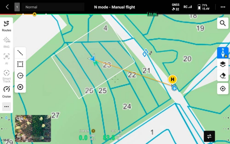
The forest stand thematic layer displays forest stand boundaries and identification numbers based on data from the Estonian Forest Register.
During flight, you can immediately see which forest stand the drone is currently flying over.
This is an essential tool for forest owners, forestry consultants and forestry professionals – helping with harvesting planning, damage mapping and verification of completed work.
Cadastral Parcels
The cadastral parcel thematic layer displays property boundaries based on data from the Estonian Land and Spatial Development Board.
This allows you to see property boundaries while flying.
The layer is suitable for real estate photography, agricultural and forestry work, construction site inspections or simply checking your own property.
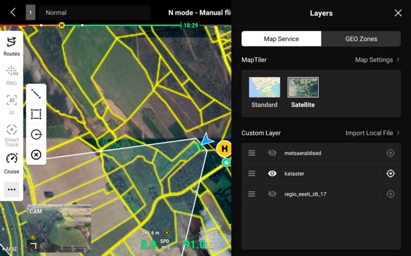
NB! The thematic drone map layers do not include a basemap. If you do not already have the Regio Estonia Basemap installed on your controller, we recommend purchasing it together with the thematic layers.
Custom Maps
Custom Maps
In addition to our standard products, we also offer customised maps for drone controllers.
Do you need a map layer showing your company’s routes, facilities, work areas or other spatial data? We can take your data, process it into a suitable format and design it to ensure clear and readable display on your controller’s screen.
Contact us at maps@regio.ee.
First tested by Luua Forestry School
First tested by Luua Forestry School
Luua Forestry School was the first to test Regio Drone Maps. Lauri Toim, who teaches drone technology at the school, tested the maps using a DJI Matrice 4E drone and an RC Plus 2 Enterprise controller.
During testing, Lauri highlighted an important practical consideration. When the controller screen displays a large amount of information – the basemap, thematic layers and camera feed – the pilot’s attention tends to remain focused on the screen.
However, the rules for the Open Category require the drone to remain within the pilot’s visual line of sight (VLOS) throughout the flight.
For this reason, Lauri recommends having an observer as part of the team. The observer monitors the drone itself during flight and ensures that it remains within visual line of sight, while the pilot can concentrate on the controller and the map.
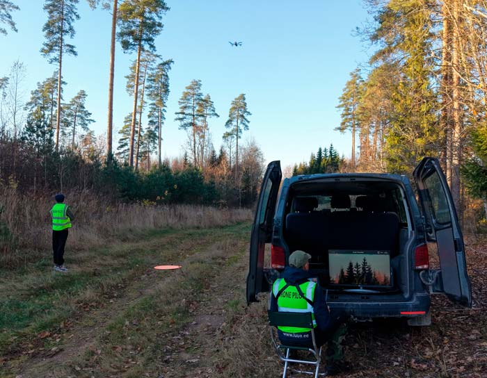
Another practical recommendation is to use an external monitor. The controller can transmit its video feed via HDMI to a larger screen, allowing the camera view to remain visible in full-screen mode.
An external monitor is particularly useful when monitoring operations together with colleagues. Looking over someone’s shoulder at the controller screen is uncomfortable and can interfere with the piloting process.
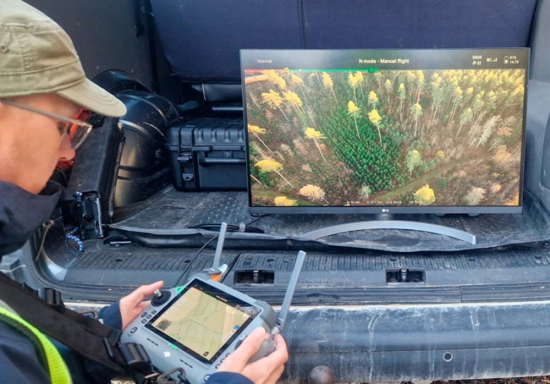
Lauri, who teaches drone-related subjects at Luua Forestry School, considers promoting safe drone operations to be his mission.
At Regio, we fully support this approach: a good map makes work more efficient, but safety always comes first.
Many thanks to Lauri Toim and Luua Forestry School for their thorough testing and valuable recommendations!
If you need a customised map or have any questions, contact us at maps@regio.ee or call +372 5566 7787.
Photos and screenshots: Lauri Toim, Luua Forestry School
 Kaspar Uba


