From Excel to Map – The Mapping Application as a Strategic Tool
Automatic Translation by ChatGPT
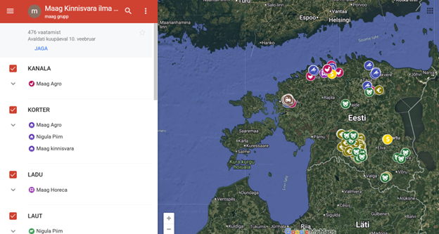
When Maag Group acquired HKScan’s Baltic businesses, the deal included a large variety of real estate – farmland, factories, warehouses, apartments, barns, and canals. Reviewing and managing all of this in Excel spreadsheets soon proved to be complicated and time-consuming. The company therefore decided to visualize all the information on a map to get a better overview of the locations of their properties. “We then turned to Regio, and that’s how our Google Maps–based mapping application came to be,” explains Ivo Vinogradov, representative of Maag Food OÜ.
All Real Estate on a Single Map
The main goal was to gain an overview of where the company’s properties are located across Estonia. Objects were categorized – factories, canals, pig farms, leased land, etc. – and plotted on Google Maps.
The resulting mapping application offers Maag several advantages:
- Filtering: Only specific types of properties can be displayed as needed.
- Leased land management: The map immediately shows which fields are leased and which are available.
- Overview of properties for sale: Information is quickly accessible, and removing objects takes just a few clicks.
- Distance measurement: For example, in the case of pig farms, it is possible to estimate economically feasible transport distances for manure (e.g., within a 25 km radius).
- Presenting information to partners: The map is a convenient tool for showing property locations to banks and other partners.
Future-Oriented Solution
Currently, all of Maag Food’s properties in Estonia can be managed in one place and understood visually. The next step is to plot properties in neighboring countries on the map.
It is also important that daily use of the mapping application does not incur direct additional costs, at least with a small usage volume. “The map is free – the only initial effort was mapping our requirements and entering the objects. Later, we can add new objects ourselves if needed or request Regio’s assistance,” explains a representative of Maag Food.
Although Regio has previously created several mapping applications based on its own platform, for this project we decided to use an alternative solution – a combination of Google Maps and Google Spreadsheets, which better met the client’s expectations.
It is worth noting, however, that using Google Maps is not always completely free. For small usage volumes, Google’s monthly $200 credit generally covers the costs. If the number of map requests increases or more functions are used, the free limit can be quickly exceeded. Prices depend on the type and volume of requests, so it is wise to monitor usage and optimize as needed.
Summary
Maag Food’s experience shows how a simple mapping application can make complex property management easy and visually clear, supporting both daily operations and strategic decisions.
Handling all kinds of data is Regio’s everyday work. In addition to creating applications, we offer a wide range of GIS services, from development and database migration to consulting and expert support.
 Kaspar Uba
