APIs as the modern communication language of digital solutions
Automatic Translation by ChatGPT
Modern digital solutions rarely consist of a single, closed system. Map applications, web forms, and information systems need to exchange data with each other quickly and automatically. This is made possible through APIs (short for Application Programming Interface).
Put simply, an API is an agreed set of rules that defines how software systems exchange information: one system sends a request, another responds, and both know in advance the structure and format of that interaction. Thanks to APIs, different solutions work seamlessly together from the user’s perspective, without the technical complexity being visible.

An API allows systems to request data and trigger operations without needing to know how the other system works internally.
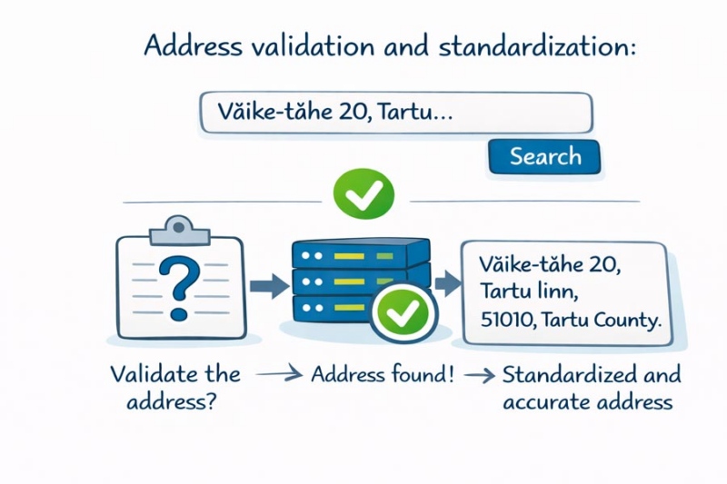
Imagine a web form where a user starts entering an address.
- The user types: Väike-tähe 20, Tartu.
- The application sends a request via an API to an address data service.
- The API checks whether the address exists and is valid.
- In response, it returns a standardized and accurate address: Väike-tähe 20, Tartu linn, Tartu linn, Tartumaa, 51010, Estonia.
Another common API use case is displaying an address on a map.
- The application receives an address from the user: Väike-Tähe 20, Tartu.
- The address is sent via an API to a geocoding service.
- The API returns precise geographic coordinates: 58.372355, 26.720251.
- The application then displays the location as a point on the map.
For the user, this appears as a simple map view. In the background, however, multiple systems work together seamlessly, coordinated and enabled by a central API.

Regio API services allow accurate and up-to-date location data from Estonia, Latvia, and Lithuania to be used directly within digital solutions. Instead of downloading files or managing datasets manually, data can be queried automatically and in real time from the Regio database.
What can you use Regio API services for?
Address validation and standardization
The Regio API helps verify whether an entered address exists and returns it in a correct, standardized format. This reduces invalid addresses and improves data quality already at the point of data entry.
Geocoding – converting addresses into coordinates
Using the API, a textual address can be converted into precise geographic coordinates. These coordinates can then be used in map applications, navigation solutions, and location-based services.
Route and distance calculations (routing)
The Regio API enables the calculation of routes and distances between different locations. This makes it possible to assess how far objects are from each other and determine the most suitable travel route.
Location-based queries
The API supports spatial queries, such as finding the nearest objects or checking whether an address falls within a specific service or delivery area.
Where is the Regio API used?
The Regio API is used in a wide range of digital solutions, for example:
E-commerce platforms
In checkout processes and user account creation, for automatic address completion and validation. This helps reduce incorrect entries and improves delivery accuracy.
Logistics and courier solutions
For address validation, geocoding, and the precise definition of routes and delivery areas.
Customer management and business software (CRM/ERP)
To clean and standardize customer data, enrich records with spatial information, and support data-driven business decisions.
Map applications and analytics
For displaying objects and addresses on maps, analyzing spatial patterns, and visualizing geospatial data.
In all of these cases, the goal is the same: data flows automatically and remains up to date and reliable.
In summary, an API is the modern communication layer that enables digital solutions to work together. Regio API services give this communication real value by providing high-quality, accurate location data for the Baltic States—ready to be used exactly where it is needed.
 Kaspar Uba
