Collection of detailed geospatial data
Category: Geospatial data creation
The company needed precisely outlined objects related to its area of interest, along with associated infrastructure and various attributes assigned to them. We created a detailed digital twin with vector data tailored to the client’s specific requirements.
Fiber optic network planning
Category: Geospatial data processing
Regio is a cooperation partner of Estonian Fiber OÜ in fiber optic network planning, preparation of construction plans, and documentation of the built network. This involves data processing and digitization using GIS/CAD software, where our skills in interpreting orthophotos, understanding the principles of fiber optic networks, and experience in compiling, processing, and validating geospatial data are invaluable.

Transforming datasets into the appropriate format
Category: Geospatial data processing
The company had various surveys (as-built drawings, plans) created at different times for their managed assets, stored in multiple file formats, along with additional information in Excel spreadsheets. We consolidated all this data into a unified format, created a database, cleaned up the geometry, and prepared metadata documentation and a user guide.

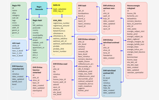
Data identification, correlation, and standardization
Category: Geospatial data processing
The company had a large address database for its clients, where the addresses were recorded in free form and contained spelling errors. The company needed the addresses to be standardized into a uniform, structured format and also wanted to retrieve certain data from the Building Register about the buildings at those addresses. We standardized the address data, retrieved the required information from the Building Register, and consolidated all of this information into a unified table.
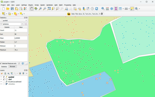
Analysis and Planning Dashboard in QGIS
Category: GIS solutions and data management
We cleaned and validated the customer address database of Saku Läte OÜ, ensuring that each address was valid and accurately referenced the building where deliveries are made. The addresses were geocoded as points on a map, and together with the water delivery route areas, we created an illustrative and informative map.
We also conducted QGIS training sessions, enabling the company’s specialists to use their own data in QGIS to:
- calculate delivery route statistics (e.g. average number of products per month),
- analyse whether the routes are over- or underloaded, and
- optimise logistics by redistributing customers between routes based on spatial relationships and statistical data.
Preparatory calculations for cash accessibility analysis
Category: Geospatial data-based analyses
We prepared calculations for cash accessibility analysis by mapping the locations of cash withdrawal points (ATMs, bank branches, store checkouts) and assessing the population’s access to them. We evaluated what proportion of the population lives at various distances from the nearest cash withdrawal point, measured along the road network. Based on this, we created overview maps and statistical comparisons that provide the necessary input data for further analysis.

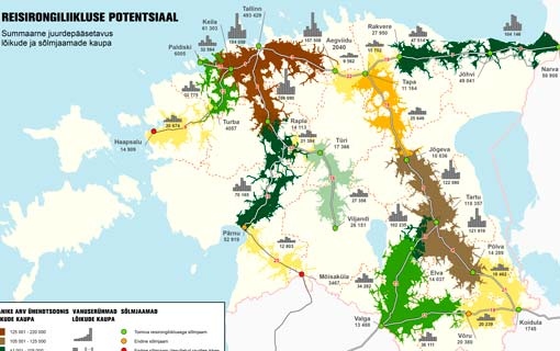
Rail passenger transport analysis
Category: Geospatial data-based analyses
The study commissioned by the Ministry of Finance focused on assessing the potential of rail passenger transport from the perspective of daily commuting. The analysis was based on the number of people living in the railway impact area and included both active and previously serviced rail sections. This was a follow-up study, with the previous study conducted in 2010 by Regio on behalf of the Ministry of the Interior’s Planning Department.
Precise spatial data
Category: Roads and navigation
The Information Technology and Development Centre of the Ministry of the Interior (SMIT) requires accurate spatial data and GIS solutions to support various national services and analyses.
Regio has been a trusted partner for SMIT, providing spatial data, data processing, and consulting to ensure high-quality and up-to-date solutions.
Address data available via API
Category: API services
Swedbank uses Regio’s address data through an API service integrated into its portals and information systems. Address data from Estonia, Latvia, and Lithuania is available in a unified structure, simplifying the company’s workflows and reducing the need to retrieve addresses from multiple sources.

Employee transportation solution
Category: API services
Karl Storz Video Endoscopy Estonia OÜ aimed to optimize employee home-to-work and work-to-home transportation solutions to reduce its ecological footprint. Regio calculated the optimal transport routes for the shared commuting of employees.
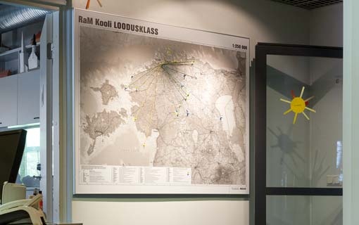
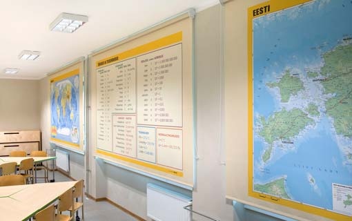
Wall maps for schools
Category: Wall maps
The Regio wall map of Estonia is designed in accordance with the school geography curriculum. Our maps of Europe and the world, as well as maps of natural zones and the solar system, are also excellent for geography classrooms. Such maps make also great educational materials at home in children’s rooms as well. There is a wide range of finishes available – from rollable paper maps to mounted, and framed versions.
Roller blinds with maps
Category: Wall maps
With a roller blind featuring a map, you get two-in-one: the map of your choice and a window covering. This solution is ideal for schools, children’s rooms, and offices alike. Any Regio wall map can be printed on the blind. The blinds are custom-made to fit the exact measurements of your window.
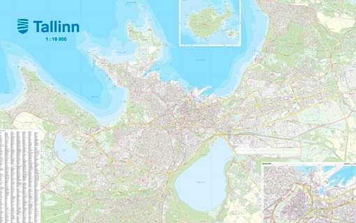
Tallinn wall maps
Category: Wall maps
Large wall maps of Tallinn (scale 1:10,000, size 226 x 172 cm) were produced on the order of the Tallinn City Government, based on the city government’s precise geodata. A total of 140 maps were printed for use in the offices and facilities of city departments and institutions.
Map on a glass wall
Category: Wall maps
Architects at Pluss Arhitektid approached Regio regarding a large map of Tallinn to be printed on a glass wall in their office. The aim was to highlight on it the buildings they had designed, thus making the glass more visible and reducing the risk of people walking into it. Since the architects had a clear vision of how the map should look, they provided us with suggestions regarding the colour scheme and design. As a result, a stylish, bespoke map was created.

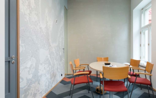
Map wallpaper
Category: Wall maps
Eye-catching map wallpaper will bring any wall to life and create a stylish home or office interior. The wallpaper can feature a map of any area requested by the customer, as well as any of Regio’s standard maps. The photo shows wallpaper with a map of Tallinn in the office of Suppa Advisers. Since the customer is a true map-lover, the end product was developed in close cooperation with them.
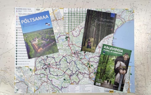
Jõgeva county maps
Category: Bespoke maps
As part of a long-term collaboration with Jõgeva County municipalities we produced them wayfinding maps, tourism brochures and hiking trail maps. In addition to creating the maps, we also compiled the information texts, arranged translations, designed the publications and organized the printing.
Map files for tourism brochures
Category: Bespoke maps
Leviring OÜ publishes an annually updated series of free tourism brochures. For this series, Regio produces maps of Estonian counties and cities, marking specific points of interest with numbered labels.
The customer receives a print-ready map file that can be added in the brochure.

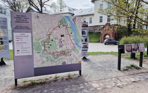
Map of the medieval city wall of Tartu
Category: Wayfinding maps
The map commissioned by the University of Tartu Museum marks the historical locations of Tartu’s medieval city wall and bastions, highlightening the visible remains of the wall. Following close consultation with the museum, in the course of which they provided us with the necessary historical information, two maps were created: an outdoor map and pocket-sized maps for museum shop.
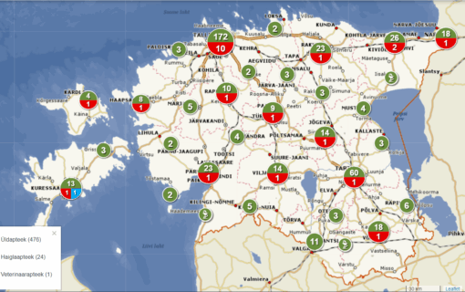
Pharmacy map application
Category: Map applications
Estonia State Agency of Medicines pharmacy map application provides an overview of pharmacies located across Estonia. The original application was developed in 2019 to support the national pharmacy reform. After the reform, the application was updated to offer an overview of all operating pharmacies in Estonia.
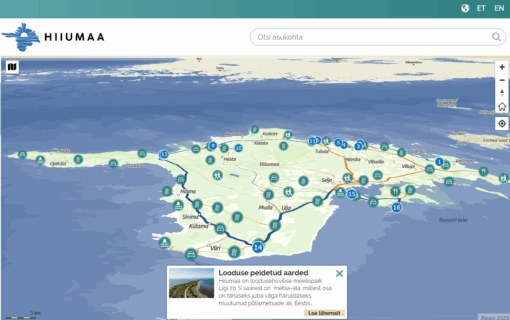
Tourism map application
Category: Map applications
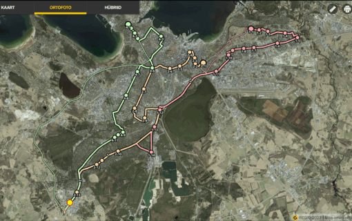
The map application commissioned by the Hiiumaa Development Centre provides an overview of attractions on Hiiumaa and suggests routes for visitors. The application is easy to use both on mobile phones and laptops.
Thank you everyone – working with you has always inspired us!

